


3G4 - Ashland County
Located in Ashland, United States
ICAO - 3G4, IATA -
Data provided by AirmateGeneral information
Coordinates: N40°54'11" W82°15'20"
Elevation is 1207 feet MSL.
Magnetic variation is -07° East View others Airports in Ohio
Operational data
Special qualification required
Current time UTC:
Current local time:
Weather at : KMFD - Mansfield Lahm Rgnl ( 24 km )
METAR: KMFD 291352Z 21015G25KT 10SM CLR 23/13 A3003 RMK AO2 SLP162 T02280128
TAF: KMFD 291120Z 2912/3012 19009KT P6SM FEW250 FM291700 21015G25KT P6SM BKN100 FM300200 23008KT P6SM VCSH OVC060 FM300500 24007KT P6SM -TSRA OVC040CB FM300800 25006KT 4SM -SHRA OVC025
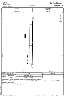
Communications frequencies: [VIEW]
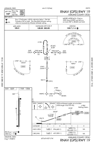
Runways:
| RWY identifier | QFU | Length (ft) | Width (ft) | Surface | LDA (ft) |
| 01 | 1° | 3501 | 75 | ASPH | |
| 19 | 181° | 3501 | 75 | ASPH |
Airport contact information
Address: Ashland United States
Other aviation service providers
Flight schools

Tailwinds Aviation Services, Inc.
Tailwinds Aviation Services, Inc.
tailwinds@3g4airport.com4192813966