


KMFD - Mansfield Lahm Rgnl
Located in Mansfield, United States
ICAO - MFD, IATA - MFD
Data provided by AirmateGeneral information
Coordinates: N40°49'17" W82°30'60"
Elevation is 1297 feet MSL.
Magnetic variation is -06° East View others Airports in Ohio
Operational data
Special qualification required
Current time UTC:
Current local time:
Communications frequencies: [VIEW]
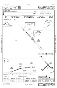
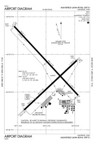
Runways:
| RWY identifier | QFU | Length (ft) | Width (ft) | Surface | LDA (ft) |
| 05 | 47° | 6819 | 150 | ASPH | 6819 |
| 23 | 227° | 6819 | 150 | ASPH | 6819 |
| 14 | 137° | 9001 | 150 | ASPH | 9001 |
| 32 | 317° | 9001 | 150 | ASPH | 9001 |
Airport contact information
Address: Mansfield United States