


30KS - Flugplatz
Located in Hutchinson, United States
ICAO - 30KS, IATA -
Data provided by AirmateGeneral information
Coordinates: N38°1'29" W97°44'2"
Elevation is 1471 feet MSL.
View others Airports in Kansas
Operational data
Special qualification required
Current time UTC:
Current local time:
Weather at : KHUT - Hutchinson Rgnl ( 12 km )
METAR: KHUT 191152Z 03011KT 10SM CLR 18/14 A2997 RMK AO2 SLP127 T01830139 10206 20167 50018
TAF: KHUT 191143Z 1912/2012 36008KT P6SM SCT120 SCT250 FM191400 15012G19KT P6SM SCT140 FM191700 16023G33KT P6SM SCT050 SCT120 SCT250 PROB30 1923/2003 VRB25G45KT 1SM +TSRA BKN040CB FM200300 15014G20KT P6SM SCT050 BKN100
Communications frequencies: [VIEW]
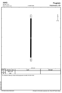
Runways:
| RWY identifier | QFU | Length (ft) | Width (ft) | Surface | LDA (ft) |
| 17 | 0° | 2597 | 50 | GRASS | |
| 35 | 0° | 2597 | 50 | GRASS |
Airport contact information
Address: Hutchinson United States