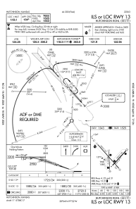
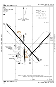


KHUT - Hutchinson Rgnl
Located in Hutchinson, United States
ICAO - HUT, IATA - HUT
Data provided by AirmateGeneral information
Coordinates: N38°3'58" W97°51'38"
Elevation is 1542 feet MSL.
Magnetic variation is 04° East View others Airports in Kansas
Operational data
Special qualification required
Current time UTC:
Current local time:
Weather
METAR: KHUT 280852Z AUTO 11006KT 10SM FEW016 SCT065 14/13 A2966 RMK AO2 LTG DSNT E RAB02E26 TSE06B11E26 SLP029 P0001 60001 T01440133 55002
TAF: KHUT 280520Z 2806/2906 18008KT P6SM SCT150 FM281100 30008KT 4SM BR BKN040 FM281300 24008KT P6SM BKN040 FM281800 23011G21KT P6SM BKN100 FM290100 30011KT P6SM SKC
Communications frequencies: [VIEW]
Runways:
| RWY identifier | QFU | Length (ft) | Width (ft) | Surface | LDA (ft) |
| 04 | 42° | 4405 | 100 | ASPH | 4401 |
| 22 | 222° | 4405 | 100 | ASPH | 4401 |
| 13 | 138° | 7003 | 100 | ASPH | 7003 |
| 31 | 318° | 7003 | 100 | ASPH | 7003 |
| 17 | 177° | 4012 | 75 | CONC | 4012 |
| 35 | 357° | 4012 | 75 | CONC | 4012 |
Airport contact information
Address: Hutchinson United States
