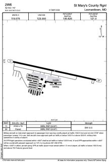


2W6 - St Mary's County Rgnl
Located in Leonardtown, United States
ICAO - 2W6, IATA -
Data provided by AirmateGeneral information
Coordinates: N38°18'55" W76°33'0"
Elevation is 142 feet MSL.
Magnetic variation is -10° East View others Airports in Maryland
Operational data
Special qualification required
Current time UTC:
Current local time:
Weather at : KNHK - Patuxent River Nas (Trapnell Fld) ( 13 km )
METAR: KNHK 131452Z COR VRB05KT 10SM FEW024 FEW250 20/12 A3012 RMK AO2 SLP198 T02000117 53004
TAF: TAF AMD KNHK 1308/1407 VRB06KT 9999 FEW015 SCT025 QNH3000INS BECMG 1314/1316 16012G18KT 9999 FEW100 QNH3004INS BECMG 1318/1320 16012G18KT 9999 FEW250 QNH3000INS AUTOMATED SENSOR METWATCH 1307 TIL 1308 TX20/1320Z TN11/1310Z AMD 0820 FN00266
Communications frequencies: [VIEW]
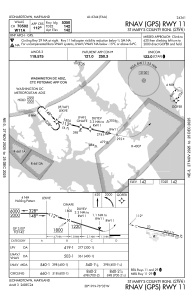
Runways:
| RWY identifier | QFU | Length (ft) | Width (ft) | Surface | LDA (ft) |
| 11 | 102° | 4150 | 75 | ASPH | |
| 29 | 282° | 4150 | 75 | ASPH |
Airport contact information
Address: Leonardtown United States

