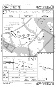
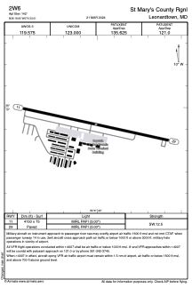


2W6 - St Mary's County Rgnl
Located in Leonardtown, United States
ICAO - 2W6, IATA -
Data provided by AirmateGeneral information
Coordinates: N38°18'55" W76°33'0"
Elevation is 142 feet MSL.
Magnetic variation is -10° East View others Airports in Maryland
Operational data
Special qualification required
Current time UTC:
Current local time:
Communications frequencies: [VIEW]
Runways:
| RWY identifier | QFU | Length (ft) | Width (ft) | Surface | LDA (ft) |
| 11 | 102° | 4150 | 75 | ASPH | |
| 29 | 282° | 4150 | 75 | ASPH |
Airport contact information
Address: Leonardtown United States

