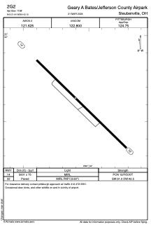


2G2 - Geary A Bates/Jefferson County Airpark
Located in Steubenville, United States
ICAO - 2G2, IATA -
Data provided by AirmateGeneral information
Coordinates: N40°21'38" W80°42'6"
Elevation is 1198 feet MSL.
Magnetic variation is -08° East View others Airports in Ohio
Operational data
Special qualification required
Current time UTC:
Current local time:
Weather at : KHLG - Wheeling Ohio County ( 21 km )
METAR: KHLG 301953Z 25005KT 10SM BKN026 BKN041 OVC060 20/14 A2992 RMK AO2 SLP130 T02000139
TAF: KHLG 301738Z 3018/0118 28008KT P6SM BKN035 FM301900 27009KT P6SM BKN025 FM302100 28007KT P6SM BKN035 FM010100 27005KT P6SM SCT200
Communications frequencies: [VIEW]
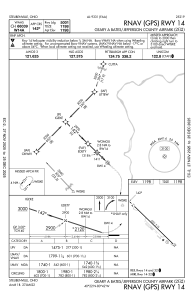
Runways:
| RWY identifier | QFU | Length (ft) | Width (ft) | Surface | LDA (ft) |
| 14 | 134° | 5001 | 75 | ASPH | |
| 32 | 314° | 5001 | 75 | ASPH |
Airport contact information
Address: Steubenville United States
