


KHLG - Wheeling Ohio County
Located in Wheeling, United States
ICAO - HLG, IATA - HLG
Data provided by AirmateGeneral information
Coordinates: N40°10'30" W80°38'47"
Elevation is 1194 feet MSL.
Magnetic variation is -07° East View others Airports in West Virginia
Operational data
Special qualification required
Current time UTC:
Current local time:
Weather
METAR: KHLG 011753Z 20010G16KT 10SM CLR 24/09 A2997 RMK AO2 SLP145 T02390089 10244 20117 56018
TAF: KHLG 011720Z 0118/0218 22009KT P6SM SCT120 FM020000 21004KT P6SM SCT250 FM021400 01004KT P6SM SCT250
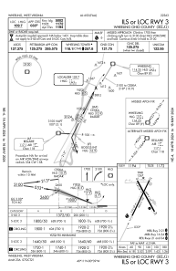
Communications frequencies: [VIEW]
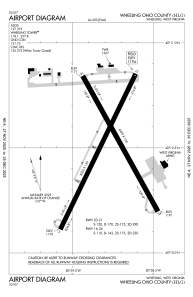
Runways:
| RWY identifier | QFU | Length (ft) | Width (ft) | Surface | LDA (ft) |
| 03 | 26° | 5002 | 150 | ASPH | |
| 21 | 206° | 5002 | 150 | ASPH | |
| 16 | 151° | 4499 | 150 | ASPH | |
| 34 | 331° | 4499 | 150 | ASPH |
Airport contact information
Address: Wheeling United States