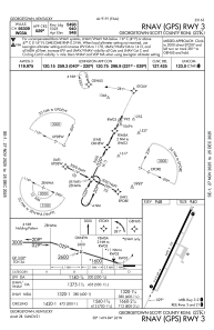
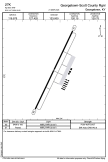


27K - Georgetown-Scott County Rgnl
Located in Georgetown, United States
ICAO - 27K, IATA -
Data provided by AirmateGeneral information
Coordinates: N38°14'4" W84°26'5"
Elevation is 948 feet MSL.
Magnetic variation is -03° East View others Airports in Kentucky
Operational data
Special qualification required
Current time UTC:
Current local time:
Weather at : KLEX - Blue Grass ( 27 km )
METAR: KLEX 140254Z 16010KT 10SM BKN016 OVC027 17/13 A2991 RMK AO2 SLP121 T01720133 51011
TAF: KLEX 132340Z 1400/1424 18011KT P6SM BKN050 OVC100 FM140300 17008KT P6SM OVC050 FM141100 16007KT 6SM -SHRA SCT015 BKN021 FM141400 16009KT 6SM -SHRA SCT009 BKN015 FM141800 18008KT 6SM -SHRA VCTS BKN025CB
Communications frequencies: [VIEW]
Runways:
| RWY identifier | QFU | Length (ft) | Width (ft) | Surface | LDA (ft) |
| 03 | 26° | 5498 | 100 | ASPH | |
| 21 | 206° | 5498 | 100 | ASPH |
Airport contact information
Address: Georgetown United States
Other aviation service providers
Flight schools

Officer Don Flight Training Academy
Officer Don Flight Training Academy
don@officerdon.com+1(859)422-8727