


KLEX - Blue Grass
Located in Lexington, United States
ICAO - LEX, IATA - LEX
Data provided by AirmateGeneral information
Coordinates: N38°2'12" W84°36'31"
Elevation is 979 feet MSL.
Magnetic variation is -04° East View others Airports in Kentucky
Operational data
Special qualification required
Current time UTC:
Current local time:
Weather
METAR: KLEX 281554Z 21011G19KT 10SM CLR 25/16 A3017 RMK AO2 SLP209 T02500156 $
TAF: KLEX 281120Z 2812/2912 17007KT P6SM FEW250 FM281400 20012G20KT P6SM SCT050 FM290000 18008KT P6SM BKN250
Communications frequencies: [VIEW]
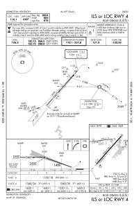
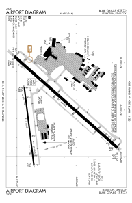
Runways:
| RWY identifier | QFU | Length (ft) | Width (ft) | Surface | LDA (ft) |
| 04 | 42° | 7004 | 150 | ASPH | 6604 |
| 22 | 222° | 7004 | 150 | ASPH | 6604 |
| 09 | 83° | 4000 | 75 | CONC | 4000 |
| 27 | 263° | 4000 | 75 | CONC | 4000 |
Airport contact information
Address: Lexington United States

