


1L9 - Parowan
Located in Parowan, United States
ICAO - 1L9, IATA -
Data provided by AirmateGeneral information
Coordinates: N37°51'35" W112°48'57"
Elevation is 5930 feet MSL.
Magnetic variation is 14° East View others Airports in Utah
Operational data
Special qualification required
Current time UTC:
Current local time:
Weather at : KCDC - Cedar City Rgnl ( 30 km )
METAR: KCDC 151553Z AUTO 00000KT 10SM CLR 16/02 A3002 RMK AO2 SLP106 T01610022
TAF: KCDC 151120Z 1512/1612 15006KT P6SM SCT150 FM151700 35007KT P6SM FEW150 FM151900 35010G20KT P6SM FEW080 FEW250 FM160220 01009KT P6SM SKC
Communications frequencies: [VIEW]
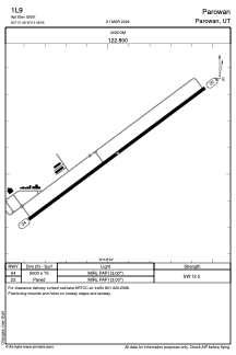
Runways:
| RWY identifier | QFU | Length (ft) | Width (ft) | Surface | LDA (ft) |
| 04 | 53° | 5000 | 75 | ASPH | |
| 22 | 233° | 5000 | 75 | ASPH |
Airport contact information
Address: Parowan United States