


14S - Westport
Located in Westport, United States
ICAO - 14S, IATA -
Data provided by AirmateGeneral information
Coordinates: N46°53'49" W124°6'3"
Elevation is 14 feet MSL.
Magnetic variation is 20° East View others Airports in Washington
Operational data
Special qualification required
Current time UTC:
Current local time:
Weather at : KHQM - Bowerman ( 15 km )
METAR: KHQM 182353Z AUTO 28015G27KT 10SM FEW027 SCT042 SCT110 13/06 A3012 RMK AO2 PK WND 27027/2346 SLP203 T01280061 10133 20111 55001
TAF: KHQM 182332Z 1900/1924 28014G24KT P6SM VCSH FEW030 BKN035 FM190200 29009KT P6SM SCT025 BKN035 FM191800 27011KT P6SM OVC050
Communications frequencies: [VIEW]
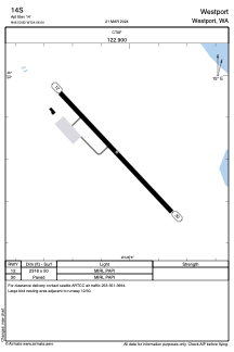
Runways:
| RWY identifier | QFU | Length (ft) | Width (ft) | Surface | LDA (ft) |
| 12 | 137° | 2318 | 50 | ASPH | |
| 30 | 317° | 2318 | 50 | ASPH |
Airport contact information
Address: Westport United States