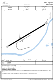


12V - Ona Airpark
Located in Milton, United States
ICAO - 12V, IATA -
Data provided by AirmateGeneral information
Coordinates: N38°26'27" W82°12'3"
Elevation is 572 feet MSL.
Magnetic variation is -06° East View others Airports in West Virginia
Operational data
Special qualification required
Current time UTC:
Current local time:
Weather at : KHTS - Tri-State/Milton J Ferguson Fld ( 32 km )
METAR: KHTS 160951Z 30003KT 7SM OVC006 18/16 A2982 RMK AO2 SLP090 T01780156 $
TAF: KHTS 160853Z 1609/1706 VRB03KT 6SM BR VCFG OVC005 TEMPO 1609/1613 3/4SM BR OVC001 FM161300 00000KT 6SM BR BKN007 FM161500 00000KT P6SM BKN013 FM161800 VRB03KT P6SM SCT050
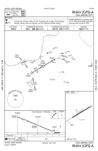
Communications frequencies: [VIEW]
Runways:
| RWY identifier | QFU | Length (ft) | Width (ft) | Surface | LDA (ft) |
| 07 | 59° | 3154 | 40 | ASPH | |
| 25 | 239° | 3154 | 40 | ASPH |
Airport contact information
Address: Milton United States
