


0XA4 - Seven C's Ranch
Located in Freer, United States
ICAO - 0XA4, IATA -
Data provided by AirmateGeneral information
Coordinates: N27°59'50" W98°52'58"
Elevation is 336 feet MSL.
Magnetic variation is 05° East View others Airports in Texas
Operational data
Special qualification required
Current time UTC:
Current local time:
Weather at : KCOT - Cotulla-La Salle County ( 61 km )
METAR: KCOT 160553Z AUTO 11010KT 10SM OVC022 27/22 A2973 RMK AO2 SLP059 T02720222 10339 20267 403670189 51005
TAF: KCOT 160520Z 1606/1706 12011KT P6SM FEW035 FM161900 17009KT P6SM BKN040
Communications frequencies: [VIEW]
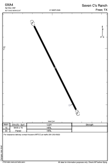
Runways:
| RWY identifier | QFU | Length (ft) | Width (ft) | Surface | LDA (ft) |
| 15 | 0° | 5005 | 75 | ASPH | |
| 33 | 0° | 5005 | 75 | ASPH |
Airport contact information
Address: Freer United States