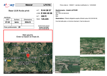


LF4755 - Mascar
Located in Saint-Martin-de-Villeréal, France
ICAO - , IATA -
Data provided by AirmateGeneral information
Coordinates: N44°38'57" E0°49'8"
Elevation is 300 feet MSL.
View others Airports in Aquitaine
Operational data
Special qualification required
Current time UTC:
Current local time:
Weather at : LFBE - Bergerac Dordogne Perigord ( 31 km )
METAR: LFBE 290930Z AUTO VRB03KT CAVOK 17/13 Q1019 TEMPO 3000 RA BKN010
TAF: TAF LFBE 290500Z 2906/3006 VRB02KT CAVOK BECMG 2910/2912 28010KT BECMG 2909/2911 BKN030 TEMPO 2911/3006 3000 RA BKN010 PROB40 TEMPO 3000/3006 1500 RADZ BKN002 BKN005
Communications frequencies: [VIEW]
Runways:
| RWY identifier | QFU | Length (ft) | Width (ft) | Surface | LDA (ft) |
| 07 | 0° | 1148 | 32 | DIRT | |
| 25 | 0° | 1148 | 32 | DIRT |
Airport contact information
Address: Saint-Martin-de-Villeréal France