


EGCE15 - Calton Moor
Located in , United Kingdom
ICAO - , IATA -
Data provided by AirmateGeneral information
Coordinates: N53°1'58" W1°50'6"
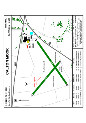
Elevation is 990 feet MSL.
Magnetic variation is -1° East View others Airports in England
Operational data
Special qualification required
Current time UTC:
Current local time:
Weather at : EGNX - East Midlands ( 41 km )
METAR: EGNX 232320Z 24010KT 9999 BKN020 11/08 Q1015
TAF: TAF EGNX 232255Z 2400/2424 24008KT 9999 BKN020 TEMPO 2400/2410 BKN010 PROB30 TEMPO 2400/2410 6000 -RADZ BKN007 PROB30 TEMPO 2410/2412 6000 -RADZ
Communications frequencies: [VIEW]
Runways:
| RWY identifier | QFU | Length (ft) | Width (ft) | Surface | LDA (ft) |
| 24 | 0° | 1640 | 65 | GRASS | |
| 06 | 0° | 1640 | 65 | GRASS |
Airport contact information
Address: United Kingdom