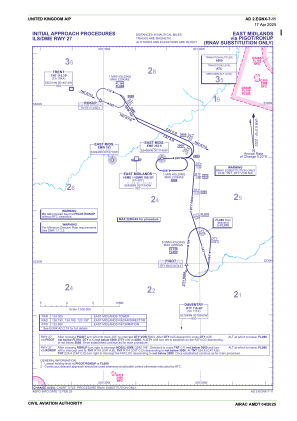
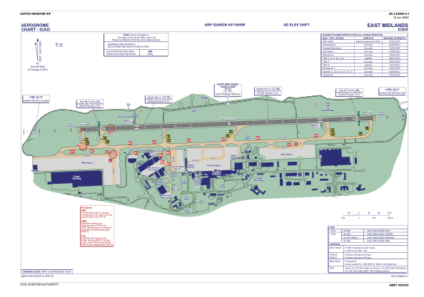


EGNX - East Midlands
Located in Derby, United Kingdom
ICAO - EGNX, IATA - EMA
Data provided by AirmateGeneral information
Coordinates: N52°49'52" W1°19'40"
Elevation is 306 feet MSL.
View others Airports in England
Operational data
Special qualification required
Current time UTC:
Current local time:
Weather
METAR: EGNX 271220Z 07010KT 9999 FEW028 SCT032 10/03 Q1005
TAF: TAF EGNX 271057Z 2712/2812 05009KT 9999 SCT015 PROB40 TEMPO 2712/2721 8000 -RA BKN012 BECMG 2721/2724 8000 -RA OVC010 TEMPO 2723/2810 4000 RADZ BKN006 PROB40 TEMPO 2800/2808 +RA BECMG 2803/2806 34012KT BECMG 2810/2812 28012KT 9999 SCT020
Communications frequencies: [VIEW]
Runways:
| RWY identifier | QFU | Length (ft) | Width (ft) | Surface | LDA (ft) |
| 09 | 88° | 9495 | 148 | ASP | |
| 27 | 268° | 9495 | 148 | ASP |
Airport contact information
Address: Derby United Kingdom
Handlers

Other aviation service providers
Flight schools

Looporder Limited T/A East Midlands Helicopters
Looporder Limited T/A East Midlands Helicopters
sales@eastmidlandshelicopters.com+44 01509856464