


39Z - Flying-A-Ranch
Located in Fruitport, United States
ICAO - 39Z, IATA -
Data provided by AirmateGeneral information
Coordinates: N43°6'18" W86°7'17"
Elevation is 630 feet MSL.
Magnetic variation is -03° East View others Airports in Michigan
Operational data
Special qualification required
Current time UTC:
Current local time:
Weather at : KMKG - Muskegon County ( 12 km )
TAF: KMKG 080536Z 0806/0906 20005KT P6SM SCT250 FM081500 22007KT P6SM OVC100 FM081800 32006KT P6SM -RA OVC050 FM082100 34005KT 5SM -RA BR OVC035 FM082300 12004KT 4SM -RA BR OVC025 FM090100 29004KT P6SM OVC050
Communications frequencies: [VIEW]
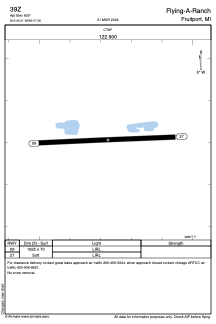
Runways:
| RWY identifier | QFU | Length (ft) | Width (ft) | Surface | LDA (ft) |
| 09 | 87° | 1925 | 70 | GRASS | |
| 27 | 267° | 1925 | 70 | GRASS |
Airport contact information
Address: Fruitport United States