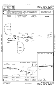


10G - Holmes County
Located in Millersburg, United States
ICAO - 10G, IATA -
Data provided by AirmateGeneral information
Coordinates: N40°32'12" W81°57'21"
Elevation is 1227 feet MSL.
Magnetic variation is -08° East View others Airports in Ohio
Operational data
Special qualification required
Current time UTC:
Current local time:
Weather at : KBJJ - Wayne County ( 38 km )
METAR: KBJJ 041756Z AUTO 15008KT 10SM FEW047 FEW060 29/18 A2993 RMK AO2 SLP127 T02940183 10294 20206 58009
Communications frequencies: [VIEW]
Runways:
| RWY identifier | QFU | Length (ft) | Width (ft) | Surface | LDA (ft) |
| 09 | 87° | 4400 | 75 | ASPH | |
| 27 | 267° | 4400 | 75 | ASPH |
Airport contact information
Address: Millersburg United States