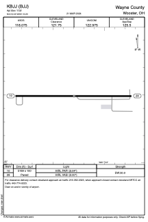


KBJJ - Wayne County
Located in Wooster, United States
ICAO - BJJ, IATA - BJJ
Data provided by AirmateGeneral information
Coordinates: N40°52'29" W81°53'18"
Elevation is 1135 feet MSL.
Magnetic variation is -07° East View others Airports in Ohio
Operational data
Special qualification required
Current time UTC:
Current local time:
Weather
METAR: KBJJ 280556Z AUTO 22009KT 10SM CLR 20/14 A3012 RMK AO2 SLP192 60000 T02000139 10233 20200 58005
Communications frequencies: [VIEW]
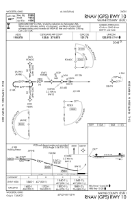
Runways:
| RWY identifier | QFU | Length (ft) | Width (ft) | Surface | LDA (ft) |
| 10 | 90° | 5189 | 100 | ASPH | |
| 28 | 270° | 5189 | 100 | ASPH |
Airport contact information
Address: Wooster United States