logo
Search for airport 
image banner adimage banner adimage banner ad
image banner ad

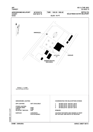
LTHE - Antalya Suleyman Satir Military Heliport

Located in Antalya, Turkey

ICAO - , IATA -

Data provided by Airmate  

General information

Coordinates: N36°50'2" E30°36'12"
Elevation is 10 feet MSL.
Magnetic variation is 4.0° East
View others Airports in Antalya

Operational data

Special qualification required
Current time UTC:
Current local time:
Weather at : LTAI - Antalya ( 18 km )
METAR: LTAI 300520Z 35006KT 300V040 9999 FEW030 25/17 Q1012 NOSIG
TAF: TAF LTAI 292240Z 3000/3024 34006KT CAVOK BECMG 3000/3003 SCT030 BECMG 3006/3009 18010KT FEW020CB BKN030 PROB40 TEMPO 3010/3014 -TSRA TEMPO 3014/3018 VRB15G25KT -TSRA BECMG 3018/3021 34006KT SCT030
View NOTAMs / SUP AIP / TFR affecting this airport [VIEW]
Communications frequencies: [VIEW]

Runways:

Airport contact information

Address: Antalya Turkey

Satellite view of LTHE