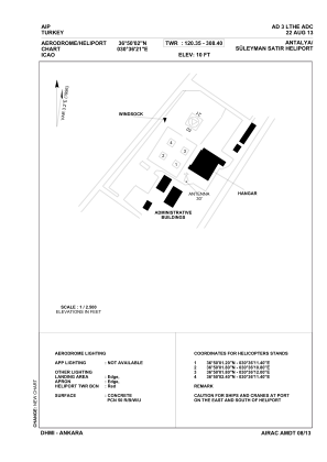


LTHE - Antalya Suleyman Satir Military Heliport
Located in Antalya, Turkey
ICAO - , IATA -
Data provided by AirmateGeneral information
Coordinates: N36°50'2" E30°36'12"
Elevation is 10 feet MSL.
Magnetic variation is 4.0° East View others Airports in Antalya
Operational data
Special qualification required
Current time UTC:
Current local time:
Weather at : LTAI - Antalya ( 18 km )
METAR: LTAI 070250Z 34005KT CAVOK 15/03 Q1012 NOSIG RMK RWY18C 32005KT RWY36R 35006KT RWY18L 33004KT 300V010
TAF: TAF LTAI 062240Z 0700/0724 34009KT CAVOK BECMG 0707/0710 20015KT BECMG 0715/0718 VRB02KT
Communications frequencies: [VIEW]
Runways:
Airport contact information
Address: Antalya Turkey