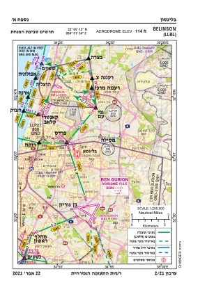


LLBL - Beilinson Hospital
Located in פ"ת, Israel
ICAO - , IATA -
Data provided by AirmateGeneral information
Coordinates: N32°5'13" E34°51'54"
Elevation is 114 feet MSL.
Magnetic variation is 5° East View others Airports in Tel Aviv District
Operational data
Special qualification required
Current time UTC:
Current local time:
Weather at : LLBG - Tel-Aviv/Ben-Gurion ( 9 km )
METAR: LLBG 260850Z 26006KT 9999 FEW018 BKN025 25/18 Q1009 NOSIG
TAF: TAF LLBG 260506Z 2606/2706 21007KT 8000 SCT020 BECMG 2608/2610 29010KT NSC BECMG 2615/2617 VRB04KT 9999 SCT023 PROB40 TEMPO 2622/2705 19006KT BKN018 TX28/2611Z TN20/2704Z
Communications frequencies: [VIEW]
Runways:
Airport contact information
Address: פ"ת Israel