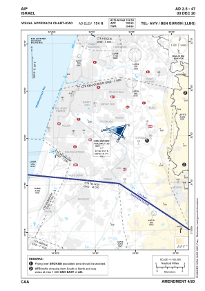
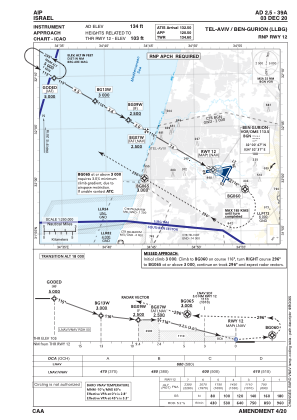
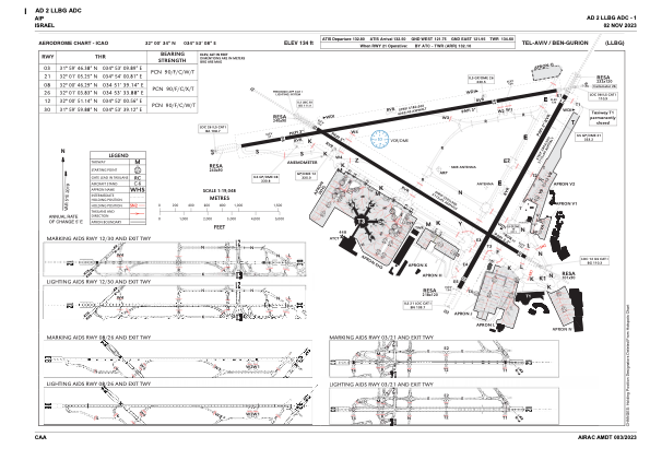


LLBG - Tel-Aviv/Ben-Gurion
Located in Tel Aviv, Israel
ICAO - LLBG, IATA - TLV
Data provided by AirmateGeneral information
Coordinates: N32°0'34" E34°53'8"
Elevation is 134 feet MSL.
Magnetic variation is 5° East View others Airports in Center District
Operational data
Special qualification required
Current time UTC:
Current local time:
Weather
METAR: LLBG 281850Z 28005KT CAVOK 21/18 Q1011 NOSIG
TAF: TAF LLBG 281704Z 2818/2918 VRB04KT 9999 SCT017 PROB40 TEMPO 2822/2905 17005KT BKN013 BECMG 2907/2909 30010KT SCT030 TX26/2911Z TN20/2904Z
Communications frequencies: [VIEW]
Runways:
| RWY identifier | QFU | Length (ft) | Width (ft) | Surface | LDA (ft) |
| 03 | 29° | 9094 | 197 | ASPH | 9094 |
| 21 | 209° | 9094 | 197 | ASPH | 9094 |
| 08 | 80° | 13327 | 148 | ASPH | 11745 |
| 26 | 260° | 13327 | 148 | ASPH | 11358 |
| 12 | 121° | 10210 | 148 | ASPH | 10210 |
| 30 | 301° | 10210 | 148 | ASPH | 9948 |
Airport contact information
Address: Tel Aviv Israel