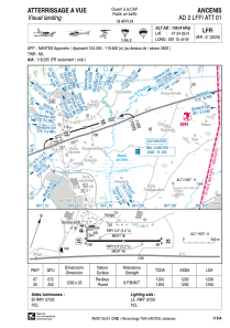


LFFI - Ancenis
Located in Ancenis, France
ICAO - LFFI, IATA -
Data provided by AirmateGeneral information
Coordinates: N47°24'26" W1°10'44"
Elevation is 109 feet MSL.
Magnetic variation is 0.03° East View others Airports in Pays-de-la-Loire
Operational data
Special qualification required
Current time UTC:
Current local time:
Weather at : LFRS - Nantes Atlantique ( 43 km )
METAR: LFRS 071000Z AUTO 35007KT 320V040 9999 BKN014 OVC021 15/13 Q1019 TEMPO 4500 -SHRA BKN020TCU
TAF: TAF AMD LFRS 070905Z 0709/0812 31006KT 9999 BKN012 BECMG 0709/0711 BKN020 PROB40 TEMPO 0711/0716 4500 -SHRA BKN020TCU BECMG 0801/0803 3500 BR BKN003 PROB40 TEMPO 0804/0806 0600 FG VV/// BECMG 0806/0809 CAVOK
Communications frequencies: [VIEW]
Runways:
| RWY identifier | QFU | Length (ft) | Width (ft) | Surface | LDA (ft) |
| 07 | 72° | 3937 | 82 | ASPH | 3937 |
| 25 | 252° | 3937 | 82 | ASPH | 3937 |
Airport contact information
Address: Ancenis France

