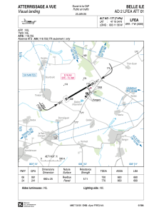


LFEA - Belle Ile
Located in Belle Ile, France
ICAO - LFEA, IATA -
Data provided by AirmateGeneral information
Coordinates: N47°19'34" W3°11'56"
Elevation is 177 feet MSL.
Magnetic variation is -0.61° East View others Airports in Brittany
Operational data
Special qualification required
Current time UTC:
Current local time:
Weather at : LFRH - Lorient Lann Bihoue ( 52 km )
METAR: LFRH 261930Z AUTO 27006KT CAVOK 09/03 Q1002 NOSIG
TAF: TAF LFRH 261700Z 2618/2718 24015KT CAVOK BECMG 2618/2620 33005KT BECMG 2707/2709 05010KT TEMPO 2709/2718 SHRA BKN018TCU PROB40 TEMPO 2714/2718 4000 SHRA SCT008CB BKN015
Communications frequencies: [VIEW]
Runways:
| RWY identifier | QFU | Length (ft) | Width (ft) | Surface | LDA (ft) |
| 06 | 60° | 2165 | 82 | ASPH | 2165 |
| 24 | 240° | 2165 | 82 | ASPH | 2165 |
Airport contact information
Address: Belle Ile France
