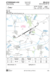


LFEA - Belle Ile
Located in Belle Ile, France
ICAO - LFEA, IATA -
Data provided by AirmateGeneral information
Coordinates: N47°19'34" W3°11'56"
Elevation is 177 feet MSL.
Magnetic variation is -0.61° East View others Airports in Brittany
Operational data
Special qualification required
Current time UTC:
Current local time:
Weather at : LFRH - Lorient Lann Bihoue ( 52 km )
METAR: LFRH 290730Z AUTO 20011KT 9999 FEW027 SCT052 12/08 Q1016 NOSIG
TAF: TAF LFRH 290500Z 2906/3006 VRB03KT 9999 SCT030 BECMG 2906/2908 21010KT TEMPO 2911/2919 21015G25KT BECMG 3001/3003 18015G25KT
Communications frequencies: [VIEW]
Runways:
| RWY identifier | QFU | Length (ft) | Width (ft) | Surface | LDA (ft) |
| 06 | 60° | 2165 | 82 | ASPH | 2165 |
| 24 | 240° | 2165 | 82 | ASPH | 2165 |
Airport contact information
Address: Belle Ile France
