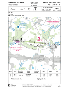


LFDF - Sainte Foy La Grande
Located in Sainte Foy La Grande, France
ICAO - LFDF, IATA -
Data provided by AirmateGeneral information
Coordinates: N44°51'9" E0°10'32"
Elevation is 282 feet MSL.
Magnetic variation is 0.59° East View others Airports in Aquitaine
Operational data
Special qualification required
Current time UTC:
Current local time:
Weather at : LFBE - Bergerac Dordogne Perigord ( 27 km )
METAR: LFBE 290400Z AUTO VRB02KT CAVOK 08/08 Q1017 TEMPO 4000 BR
TAF: TAF LFBE 282300Z 2900/2924 VRB03KT CAVOK PROB40 TEMPO 2903/2906 4000 BR NSC PROB30 TEMPO 2918/2924 -RA BKN030
Communications frequencies: [VIEW]
Runways:
| RWY identifier | QFU | Length (ft) | Width (ft) | Surface | LDA (ft) |
| 10 | 96° | 3937 | 197 | GRASS | 2854 |
| 28 | 276° | 3937 | 197 | GRASS | 3543 |
Airport contact information
Address: Sainte Foy La Grande France
