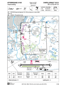


LFCA - Chatellerault Targe
Located in Chatellerault, France
ICAO - LFCA, IATA - XCX
Data provided by AirmateGeneral information
Coordinates: N46°46'49" E0°33'2"
Elevation is 210 feet MSL.
Magnetic variation is 0.60° East View others Airports in Poitou-Charentes
Operational data
Special qualification required
Current time UTC:
Current local time:
Weather at : LFBI - Poitiers Biard ( 28 km )
METAR: LFBI 272230Z AUTO 19014KT CAVOK 10/09 Q1001 TEMPO 4000 -RA BKN009 BKN020
TAF: TAF LFBI 271700Z 2718/2818 12006KT 9999 SCT030 BKN050 TEMPO 2718/2722 17015G25KT 4000 SHRA SCT012 BKN040CB PROB40 2718/2721 TSRA BECMG 2722/2724 22012KT TEMPO 2800/2807 4000 -RA BKN009 BKN020 TEMPO 2810/2818 -SHRA BKN020CB PROB40 2812/2815 TSRA
Communications frequencies: [VIEW]
Runways:
| RWY identifier | QFU | Length (ft) | Width (ft) | Surface | LDA (ft) |
| 18 | 177° | 2625 | 66 | ASPH | 2454 |
| 36 | 357° | 2625 | 66 | ASPH | 2625 |
Airport contact information
Address: Chatellerault France
