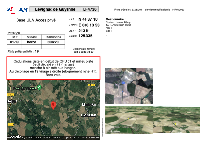


LF4736 - Lévignac de Guyenne
Located in Levignac-de-Guyenne, France
ICAO - , IATA -
Data provided by AirmateGeneral information
Coordinates: N44°37'10" E0°13'53"
Elevation is 213 feet MSL.
View others Airports in Aquitaine
Operational data
Special qualification required
Current time UTC:
Current local time:
Weather at : LFBE - Bergerac Dordogne Perigord ( 32 km )
METAR: LFBE 270230Z AUTO 08003KT 050V140 9999 -RA ///CB 10/09 Q1001 TEMPO VRB15G25KT 4000 SHRA
TAF: TAF LFBE 262300Z 2700/2724 09005KT 9999 BKN030 PROB30 TEMPO 2700/2706 VRB15G25KT 4000 SHRA FEW025CB BKN030TCU TEMPO 2706/2716 3000 SHRA BKN010 BKN020TCU PROB40 TEMPO 2712/2715 15020G35KT 1500 TSRA BKN025CB PROB30 TEMPO 2713/2715 TSGR
Communications frequencies: [VIEW]
Runways:
| RWY identifier | QFU | Length (ft) | Width (ft) | Surface | LDA (ft) |
| 01 | 0° | 1640 | 65 | GRASS | |
| 19 | 0° | 1640 | 65 | GRASS |
Airport contact information
Address: Levignac-de-Guyenne France