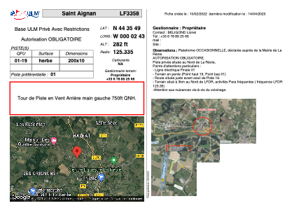


LF3358 - Saint Aignan
Located in La Réole, France
ICAO - , IATA -
Data provided by AirmateGeneral information
Coordinates: N44°35'49" W0°2'43"
Elevation is 282 feet MSL.
View others Airports in Aquitaine
Operational data
Special qualification required
Current time UTC:
Current local time:
Weather at : LFBE - Bergerac Dordogne Perigord ( 51 km )
METAR: LFBE 260130Z AUTO VRB02KT 9999 BKN009/// OVC044/// //////CB 10/09 Q1006 TEMPO 3000 -RA BKN005 OVC015
TAF: TAF LFBE 252300Z 2600/2624 24005KT 9999 BKN030 TEMPO 2600/2608 3000 -RA BKN005 OVC015 TEMPO 2608/2612 4000 SHRA BKN010 BKN030TCU
Communications frequencies: [VIEW]
Runways:
| RWY identifier | QFU | Length (ft) | Width (ft) | Surface | LDA (ft) |
| 01 | 0° | 656 | 32 | GRASS | |
| 19 | 0° | 656 | 32 | GRASS |
Airport contact information
Address: La Réole France