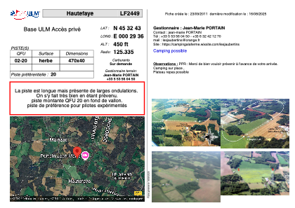


LF2449 - Hautefaye
Located in Hautefaye, France
ICAO - , IATA -
Data provided by AirmateGeneral information
Coordinates: N45°32'43" E0°29'36"
Elevation is 450 feet MSL.
View others Airports in Poitou-Charentes
Operational data
Special qualification required
Current time UTC:
Current local time:
Weather at : LFBU - Angouleme Brie Champniers ( 30 km )
METAR: LFBU 280830Z AUTO 17008KT 110V220 9999 FEW014 BKN180 ///// Q1012 BECMG FEW020TCU BKN030
TAF: TAF LFBU 280500Z 2806/2906 20010KT 9999 BKN030 TEMPO 2806/2809 BKN010 BECMG 2809/2811 FEW020TCU BKN030 PROB40 TEMPO 2812/2818 24015G25KT 4000 SHRA BKN020TCU BECMG 2818/2820 CAVOK BECMG 2823/2901 4000 BR TEMPO 2903/2906 0400 FG VV///
Communications frequencies: [VIEW]
Runways:
| RWY identifier | QFU | Length (ft) | Width (ft) | Surface | LDA (ft) |
| 02 | 0° | 1541 | 131 | GRASS | |
| 20 | 0° | 1541 | 131 | GRASS |
Airport contact information
Address: Hautefaye France