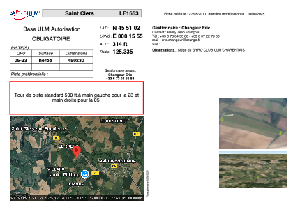


LF1653 - Saint Ciers
Located in Saint-Ciers-sur-Bonnieure, France
ICAO - , IATA -
Data provided by AirmateGeneral information
Coordinates: N45°51'2" E0°15'55"
Elevation is 314 feet MSL.
View others Airports in Poitou-Charentes
Operational data
Special qualification required
Current time UTC:
Current local time:
Weather at : LFBU - Angouleme Brie Champniers ( 14 km )
METAR: LFBU 271600Z AUTO 11004KT 040V170 9999 -RA SCT006/// SCT020/// OVC058/// ///CB ///// Q0998 TEMPO 24015G25KT 4000 SHRA
TAF: TAF AMD LFBU 271428Z 2714/2812 15010KT 9999 BKN030 TEMPO 2714/2721 24015G25KT 4000 SHRA BKN025TCU PROB40 TEMPO 2714/2716 24020G40KT 2000 TSRAGR BKN010 BKN020CB BECMG 2721/2722 21010KT PROB30 TEMPO 2721/2803 -SHRA BKN010 BKN020TCU TEMPO 2803/2809 BKN010 BECMG 2809/2811 FEW020TCU BKN030
Communications frequencies: [VIEW]
Runways:
| RWY identifier | QFU | Length (ft) | Width (ft) | Surface | LDA (ft) |
| 05 | 0° | 1476 | 98 | GRASS | |
| 23 | 0° | 1476 | 98 | GRASS |
Airport contact information
Address: Saint-Ciers-sur-Bonnieure France
Web: www.rotavia.fr