


KTXK - Texarkana Rgnl-Webb Fld
Located in Texarkana, United States
ICAO - TXK, IATA - TXK
Data provided by AirmateGeneral information
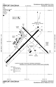
Coordinates: N33°27'13" W93°59'28"
Elevation is 389 feet MSL.
Magnetic variation is 05° East View others Airports in Arkansas
Operational data
Special qualification required
Current time UTC:
Current local time:
Weather
METAR: KTXK 281953Z 11012G22KT 10SM CLR 24/20 A2983 RMK AO2 PRESFR SLP098 T02390200
TAF: KTXK 281720Z 2818/2918 16014G24KT P6SM BKN035 FM290400 17014G21KT 4SM TSRA OVC025CB FM290900 15010KT P6SM -RA OVC025 FM291600 19004KT 4SM -RA OVC050
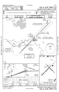
Communications frequencies: [VIEW]
Runways:
| RWY identifier | QFU | Length (ft) | Width (ft) | Surface | LDA (ft) |
| 04 | 45° | 6601 | 150 | ASPH | 6601 |
| 22 | 225° | 6601 | 150 | ASPH | 6601 |
| 13 | 135° | 5200 | 100 | ASPH | 4559 |
| 31 | 315° | 5200 | 100 | ASPH | 4559 |
Airport contact information
Address: Texarkana United States
