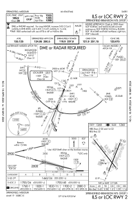
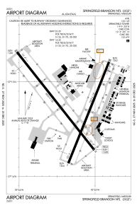


KSGF - Springfield-Branson Ntl
Located in Springfield, United States
ICAO - SGF, IATA - SGF
Data provided by AirmateGeneral information
Coordinates: N37°14'44" W93°23'19"
Elevation is 1268 feet MSL.
Magnetic variation is 03° East View others Airports in Missouri
Operational data
Special qualification required
Current time UTC:
Current local time:
Weather
METAR: KSGF 280152Z 15012KT 10SM FEW090 21/19 A2987 RMK AO2 SLP105 T02110189
TAF: KSGF 272336Z 2800/2824 16016G26KT P6SM BKN060 TEMPO 2808/2810 4SM TSRA BR OVC025CB FM281000 16016G25KT 2SM TSRA BR OVC030CB FM281200 16014G24KT 4SM TSRA BR OVC019CB FM281500 16017G27KT 4SM TSRA BR OVC027CB FM281900 17018G30KT 4SM TSRA BR BKN019CB FM282200 17016G27KT 6SM TSRA BR BKN026CB
Communications frequencies: [VIEW]
Runways:
| RWY identifier | QFU | Length (ft) | Width (ft) | Surface | LDA (ft) |
| 02 | 22° | 7003 | 150 | CONC | 7003 |
| 20 | 202° | 7003 | 150 | CONC | 7003 |
| 14 | 142° | 8000 | 150 | CONC | 8000 |
| 32 | 322° | 8000 | 150 | CONC | 8000 |
Airport contact information
Address: Springfield United States

