


KPIH - Pocatello Rgnl
Located in Pocatello, United States
ICAO - PIH, IATA - PIH
Data provided by AirmateGeneral information
Coordinates: N42°54'35" W112°35'45"
Elevation is 4451 feet MSL.
Magnetic variation is 14° East View others Airports in Idaho
Operational data
Special qualification required
Current time UTC:
Current local time:
Weather
TAF: KPIH 271409Z 2714/2812 35010KT P6SM -RA OVC025 TEMPO 2714/2717 6SM -RA BR BKN015 OVC025 FM271800 24010G19KT P6SM VCSH OVC035 FM280200 21011KT P6SM BKN060
Communications frequencies: [VIEW]
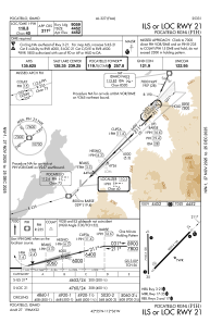
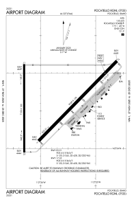
Runways:
| RWY identifier | QFU | Length (ft) | Width (ft) | Surface | LDA (ft) |
| 03 | 45° | 9059 | 150 | ASPH | 9059 |
| 21 | 225° | 9059 | 150 | ASPH | 9059 |
| 17 | 180° | 7150 | 100 | ASPH | 7150 |
| 35 | 360° | 7150 | 100 | ASPH | 7150 |
Airport contact information
Address: Pocatello United States
