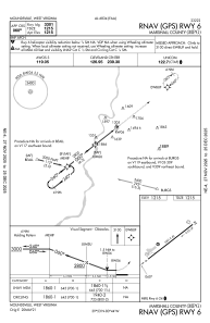
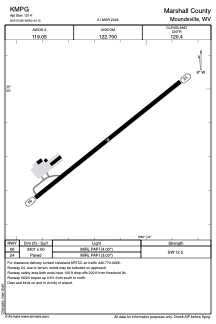


KMPG - Marshall County
Located in Moundsville, United States
ICAO - MPG, IATA -
Data provided by AirmateGeneral information
Coordinates: N39°52'51" W80°44'9"
Elevation is 1214 feet MSL.
Magnetic variation is -08° East View others Airports in West Virginia
Operational data
Special qualification required
Current time UTC:
Current local time:
Weather at : KHLG - Wheeling Ohio County ( 34 km )
METAR: KHLG 012053Z 26007KT 240V300 10SM CLR 26/08 A2993 RMK AO2 SLP133 T02610083 56012
TAF: KHLG 011720Z 0118/0218 22009KT P6SM SCT120 FM020000 21004KT P6SM SCT250 FM021400 01004KT P6SM SCT250
Communications frequencies: [VIEW]
Runways:
| RWY identifier | QFU | Length (ft) | Width (ft) | Surface | LDA (ft) |
| 06 | 52° | 3301 | 60 | ASPH | |
| 24 | 232° | 3301 | 60 | ASPH |
Airport contact information
Address: Moundsville United States