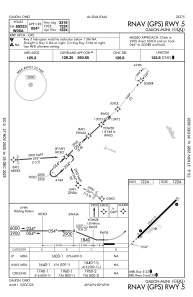
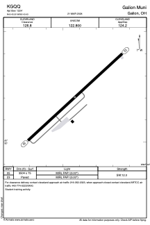


KGQQ - Galion Muni
Located in Galion, United States
ICAO - GQQ, IATA - GQQ
Data provided by AirmateGeneral information
Coordinates: N40°45'12" W82°43'26"
Elevation is 1224 feet MSL.
Magnetic variation is -07° East View others Airports in Ohio
Operational data
Special qualification required
Current time UTC:
Current local time:
Weather at : KMFD - Mansfield Lahm Rgnl ( 19 km )
METAR: KMFD 031052Z 04005KT 10SM CLR 17/11 A2996 RMK AO2 SLP135 T01670106
TAF: KMFD 030543Z 0306/0406 12005KT P6SM SCT070 BKN150 FM031000 16006KT P6SM VCSH BKN060 BKN100 TEMPO 0312/0316 5SM -SHRA BKN060 FM031600 26005KT P6SM -SHRA BKN060 TEMPO 0317/0320 4SM TSRA SCT020 OVC030CB FM032200 VRB05KT P6SM VCSH SCT030 BKN060 FM040200 03004KT P6SM BKN025
Communications frequencies: [VIEW]
Runways:
| RWY identifier | QFU | Length (ft) | Width (ft) | Surface | LDA (ft) |
| 05 | 47° | 3504 | 75 | ASPH | |
| 23 | 227° | 3504 | 75 | ASPH |
Airport contact information
Address: Galion United States
