


D69 - Rogersburg
Located in Anatone, United States
ICAO - D69, IATA -
Data provided by AirmateGeneral information
Coordinates: N46°4'27" W116°57'54"
Elevation is 869 feet MSL.
View others Airports in Washington
Operational data
Special qualification required
Current time UTC:
Current local time:
Weather at : KLWS - Lewiston/Nez Perce County ( 34 km )
METAR: KLWS 260556Z AUTO 11003KT 10SM FEW049 BKN110 11/08 A2979 RMK AO2 RAE23 SLP089 P0000 60010 T01060078 10178 20106 50003
TAF: KLWS 260520Z 2606/2706 VRB03KT 6SM -SHRA BR OVC050 FM261200 11003KT 6SM BR OVC025 FM261700 VRB03KT 6SM BR BKN035 FM262000 28004KT P6SM BKN050 PROB30 2620/2702 -SHRA
Communications frequencies: [VIEW]
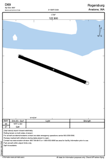
Runways:
| RWY identifier | QFU | Length (ft) | Width (ft) | Surface | LDA (ft) |
| 09 | 112° | 1471 | 50 | GRASS | |
| 27 | 292° | 1471 | 50 | GRASS |
Airport contact information
Address: Anatone United States