


D69 - Rogersburg
Located in Anatone, United States
ICAO - D69, IATA -
Data provided by AirmateGeneral information
Coordinates: N46°4'27" W116°57'54"
Elevation is 869 feet MSL.
View others Airports in Washington
Operational data
Special qualification required
Current time UTC:
Current local time:
Weather at : KLWS - Lewiston/Nez Perce County ( 34 km )
METAR: KLWS 060056Z 00000KT 10SM SCT031 BKN040 OVC048 12/08 A2967 RMK AO2 RAE28 SLP049 P0001 T01170078
TAF: KLWS 052320Z 0600/0624 29008KT P6SM -RA BKN035 OVC045 TEMPO 0602/0604 4SM -RA BKN015 OVC030 FM060500 26011KT P6SM -RA SCT015 OVC045 FM060900 25010KT P6SM BKN060 FM062000 24013G24KT P6SM VCSH SCT060 SCT150
Communications frequencies: [VIEW]
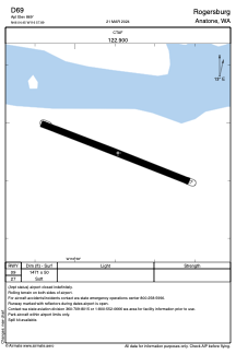
Runways:
| RWY identifier | QFU | Length (ft) | Width (ft) | Surface | LDA (ft) |
| 09 | 112° | 1471 | 50 | GRASS | |
| 27 | 292° | 1471 | 50 | GRASS |
Airport contact information
Address: Anatone United States