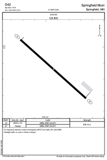


D42 - Springfield Muni
Located in Springfield, United States
ICAO - D42, IATA -
Data provided by AirmateGeneral information
Coordinates: N44°13'52" W94°59'56"
Elevation is 1073 feet MSL.
Magnetic variation is 02° East View others Airports in Minnesota
Operational data
Special qualification required
Current time UTC:
Current local time:
Weather at : KRWF - Redwood Falls Muni ( 36 km )
METAR: KRWF 081353Z AUTO 06008KT 10SM CLR 15/07 A2964 RMK AO2 SLP037 T01500072
TAF: KRWF 081120Z 0812/0912 VRB03KT P6SM SKC FM081400 09009KT P6SM SCT100 FM081700 11013G20KT P6SM SCT060 BKN100 PROB30 0821/0903 4SM -TSRA BR OVC050CB FM090300 02005KT P6SM OVC070
Communications frequencies: [VIEW]
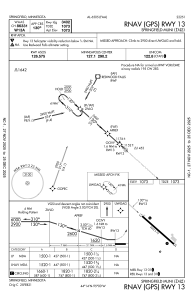
Runways:
| RWY identifier | QFU | Length (ft) | Width (ft) | Surface | LDA (ft) |
| 13 | 132° | 3402 | 75 | ASPH | |
| 31 | 312° | 3402 | 75 | ASPH |
Airport contact information
Address: Springfield United States