


14S - Westport
Located in Westport, United States
ICAO - 14S, IATA -
Data provided by AirmateGeneral information
Coordinates: N46°53'49" W124°6'3"
Elevation is 14 feet MSL.
Magnetic variation is 20° East View others Airports in Washington
Operational data
Special qualification required
Current time UTC:
Current local time:
Weather at : KHQM - Bowerman ( 15 km )
METAR: KHQM 042353Z AUTO 30008KT 7SM -RA OVC008 10/09 A2959 RMK AO2 CIG 006V013 SLP025 P0003 60017 T01000094 10106 20100 53012
TAF: KHQM 042329Z 0500/0524 29009KT 4SM -RA BR OVC007 FM050500 26009KT 6SM BR VCSH OVC006 FM052000 26013G23KT 5SM -RA BR OVC007
Communications frequencies: [VIEW]
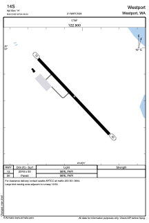
Runways:
| RWY identifier | QFU | Length (ft) | Width (ft) | Surface | LDA (ft) |
| 12 | 137° | 2318 | 50 | ASPH | |
| 30 | 317° | 2318 | 50 | ASPH |
Airport contact information
Address: Westport United States