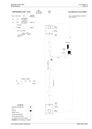


ZMSF - Nalaikh/Sky Friends
Located in Nalaikh, Mongolia
ICAO - , IATA -
Data provided by AirmateGeneral information
Coordinates: N47°46'23" E107°26'16"
Elevation is 4829 feet MSL.
View others Airports in Ulanbaatar
Operational data
Special qualification required
Current time UTC:
Current local time:
Weather at : ZMUB - Ulaanbaatar/Buyant-Ukhaa ( 51 km )
METAR: ZMUB 161700Z 00000MPS CAVOK 10/01 Q1005 NOSIG RMK QFE647.7 57
TAF: TAF ZMUB 161651Z 1618/1724 VRB02MPS 9999 SCT033 TN07/1623Z TX16/1707Z BECMG 1623/1701 35007MPS BECMG 1711/1713 VRB02MPS
Communications frequencies: [VIEW]
Runways:
| RWY identifier | QFU | Length (ft) | Width (ft) | Surface | LDA (ft) |
| 12 | 112° | 0 | 0 | UNK | |
| 30 | 292° | 0 | 0 | UNK |
Airport contact information
Address: Nalaikh Mongolia