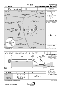
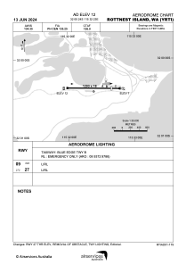


YRTI - Rottnest Island
Located in Fremantle, Australia
ICAO - YRTI, IATA - RTS
Data provided by AirmateGeneral information
Coordinates: S32°0'24" E115°32'23"
Elevation is 12 feet MSL.
View others Airports in Western Australia
Operational data
Special qualification required
Current time UTC:
Current local time:
Weather at : YPJT - Perth / Jandakot ( 34 km )
METAR: YPJT 272130Z AUTO 05004KT 9999 // BKN038 OVC043 15/14 Q1013
TAF: TAF AMD YPJT 271954Z 2719/2812 VRB05KT 9999 -SHRA FEW007 SCT050 FM280000 27010KT 9999 -SHRA SCT025 BKN050 TEMPO 2719/2723 3000 SHRA BKN008 INTER 2723/2812 4000 SHRA BKN015 PROB30 INTER 2803/2806 VRB25G35KT 2000 TSRA BKN008 SCT020CB
Communications frequencies: [VIEW]
Runways:
| RWY identifier | QFU | Length (ft) | Width (ft) | Surface | LDA (ft) |
| 09 | 90° | 4242 | 59 | ASP | |
| 27 | 270° | 4242 | 59 | ASP |
Airport contact information
Address: Fremantle Australia