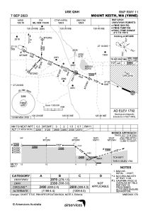
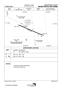


YMNE - Mount Keith
Located in Mt Keith Village, Australia
ICAO - YMNE, IATA - WME
Data provided by AirmateGeneral information
Coordinates: S27°17'11" E120°33'17"
Elevation is 1792 feet MSL.
View others Airports in Western Australia
Operational data
Special qualification required
Current time UTC:
Current local time:
Weather at : - ( 0 km )
METAR: UCFO 2770+ 27004MPS 9999 FEW040CB 19/06 Q1012 TEMPO VRB12MPS -TSRA BKN030CB
Communications frequencies: [VIEW]
Runways:
| RWY identifier | QFU | Length (ft) | Width (ft) | Surface | LDA (ft) |
| 11 | 114° | 5896 | 98 | ASP | |
| 29 | 294° | 5896 | 98 | ASP |
Airport contact information
Address: Mt Keith Village Australia