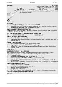


YBOA - Boonah
Located in Boonah, Australia
ICAO - YBOA, IATA -
Data provided by AirmateGeneral information
Coordinates: S28°1'3" E152°40'36"
Elevation is 330 feet MSL.
Magnetic variation is 11° East View others Airports in Northern Territory
Operational data
Special qualification required
Current time UTC:
Current local time:
Weather at : YAMB - Amberley ( 42 km )
METAR: YAMB 270600Z AUTO 12010KT 9999 // SCT061 OVC087 23/15 Q1022
TAF: TAF YAMB 270506Z 2706/2806 11010KT 9999 -SHRA SCT035 BKN050 FM270800 19004KT 9999 NSW SCT025 FM280200 11010KT 9999 -SHRA SCT030 INTER 2706/2708 4000 SHRA SCT012
Communications frequencies: [VIEW]
Runways:
| RWY identifier | QFU | Length (ft) | Width (ft) | Surface | LDA (ft) |
| 04 | 0° | 3976 | 0 | G | |
| 22 | 0° | 3976 | 0 | G | |
| YBOL | 0° | 0 | 0 | UNK |
Airport contact information
Address: Boonah Australia

