


XA66 - El Jardin Ranch
Located in Encinal, United States
ICAO - XA66, IATA -
Data provided by AirmateGeneral information
Coordinates: N28°4'26" W99°17'5"
Elevation is 485 feet MSL.
Magnetic variation is 05° East View others Airports in Texas
Operational data
Special qualification required
Current time UTC:
Current local time:
Communications frequencies: [VIEW]
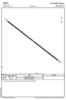
Runways:
| RWY identifier | QFU | Length (ft) | Width (ft) | Surface | LDA (ft) |
| 12 | 127° | 6302 | 80 | ASPH | |
| 30 | 307° | 6302 | 80 | ASPH |
Airport contact information
Address: Encinal United States