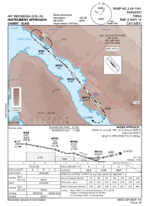
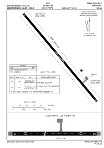


WIMP - Parapat / Sibisa
Located in Parapat, Indonesia
ICAO - WIMP, IATA - SIW
Data provided by AirmateGeneral information
Coordinates: N2°36'7" E98°57'50"
Elevation is 4234 feet MSL.
View others Airports in Sumatera Utara
Operational data
Special qualification required
Current time UTC:
Current local time:
Weather at : - ( 0 km )
METAR: KPOC 281947Z 23005KT 10SM CLR 21/08 A3001
Communications frequencies: [VIEW]
Runways:
| RWY identifier | QFU | Length (ft) | Width (ft) | Surface | LDA (ft) |
| 14 | 140° | 5348 | 98 | UNK | |
| 32 | 320° | 5348 | 98 | UNK |
Airport contact information
Address: Parapat Indonesia