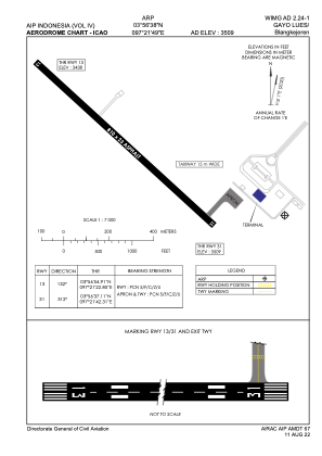


WIMG - Gayo Lues / Blangkejeren
Located in Blangkejeren, Indonesia
ICAO - WIMG, IATA - PDG
Data provided by AirmateGeneral information
Coordinates: N3°56'38" E97°21'49"
Elevation is 3509 feet MSL.
View others Airports in Sumatra Barat
Operational data
Special qualification required
Current time UTC:
Current local time:
Communications frequencies: [VIEW]
Runways:
| RWY identifier | QFU | Length (ft) | Width (ft) | Surface | LDA (ft) |
| 13 | 132° | 2657 | 75 | UNK | |
| 31 | 312° | 2657 | 75 | UNK |
Airport contact information
Address: Blangkejeren Indonesia