


WIII - Jakarta / Soekarno Hatta Intl
Located in Jakarta, Indonesia
ICAO - WIII, IATA - CGK
Data provided by AirmateGeneral information
Coordinates: S6°7'25" E106°39'40"
Elevation is 34 feet MSL.
View others Airports in Banten
Operational data
Special qualification required
Current time UTC:
Current local time:
Weather
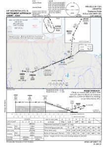
METAR: WIII 090030Z 18006KT 5000 HZ FEW020 28/23 Q1010 NOSIG
TAF: TAF WIII 082300Z 0900/1006 VRB02KT 5000 HZ FEW020 BECMG 0901/0903 05011KT 9000 NSW BECMG 0914/0916 18005KT 5000 HZ BECMG 0923/1001 VRB02KT 9000 NSW
Communications frequencies: [VIEW]
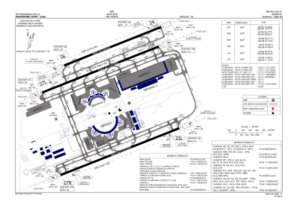
Runways:
| RWY identifier | QFU | Length (ft) | Width (ft) | Surface | LDA (ft) |
| 07R | 68° | 12008 | 197 | CON | |
| 25L | 248° | 12008 | 197 | CON | |
| 07L | 68° | 11811 | 197 | CON | |
| 25R | 248° | 11811 | 197 | CON | |
| 06 | 68° | 9843 | 197 | UNK | |
| 24 | 248° | 9843 | 197 | UNK |
Airport contact information
Address: Jakarta Indonesia